“What was I thinking?” I silently asked myself this question several times yesterday. [A few of you have pondered this same thing, questioning my sanity after I retired, joined the Peace Corps, and left the USA last year.]
Ever since arriving on the island of Dominica, I've gazed at the tall, rugged mountain behind our village. I've wondered what it would be like to hike to the top. I knew that if I ever got the chance to achieve this goal, I would always gaze up at that mountain with a new perspective of having conquered it.
Being from West Virginia, I had done some hiking up and down our hills over the course of my lifetime. During my pre-service training on the island of St. Lucia last summer, my class of Peace Corps Volunteers spent a Sunday hiking up Gros Piton, a huge mountain on that island (click here to read that story).
Gros Piton was a very challenging climb, but it is a major St. Lucia tourist attraction, with a well-maintained trail to the top. There is no well-defined trail to the top of our mountain. I knew I could not do it alone, but during a conversation with one of the men in the village, he said he would take me up there. He also told me about how there used to be a television transmitter tower on top of the mountain, which I thought would be interesting to see (the picture below shows me at the pinnacle, standing next to the small concrete block building that had been built at the base of the tower).

There is a big difference between hills here and hills in my native West Virginia. The Appalachian Mountains are old, and in weathering the centuries they have generally become more rounded. The mountains of Dominica, a “young” landmass built by volcanic eruptions, are much steeper and “sharper.” Below is a picture of the mountain behind our village, with the pinnacle being the left-most and furthest back of the three visible peaks. Notice the narrow ridges and steep slopes that converge towards the top.

Yesterday's expedition started off as just three adults, but one of my students saw us leaving, and insisted on joining us. His flip-flop started to break early on, so he hiked nearly the whole way barefoot while carrying his sandals in one hand. [The children here have much tougher feet that I do.] We took the road to the top of the village, which until yesterday had always seemed very high. Soon, I was seeing views of the village and the surrounding area that were at a higher angle than I had ever seen before (as shown below).
At the beginning, we were just working our way up a broad hillside. We came to one point where we were passing through a virtual sea of ferns that were nearly shoulder high, as shown below. It is so nice to not need to worry about poisonous snakes when hiking through such foliage, where you can't even see where you are stepping.
Eventually, we worked our way over to one of the ridges leading to the top. It was very tough to climb, with loose rocks, slippery green moss, fallen branches, exposed roots, thorny vines, etc. Often I was crawling more than climbing, using my hands to grab whatever I could to help me up the steep angle of the hill. It was beginning to seem crazy that we were climbing this mountain!
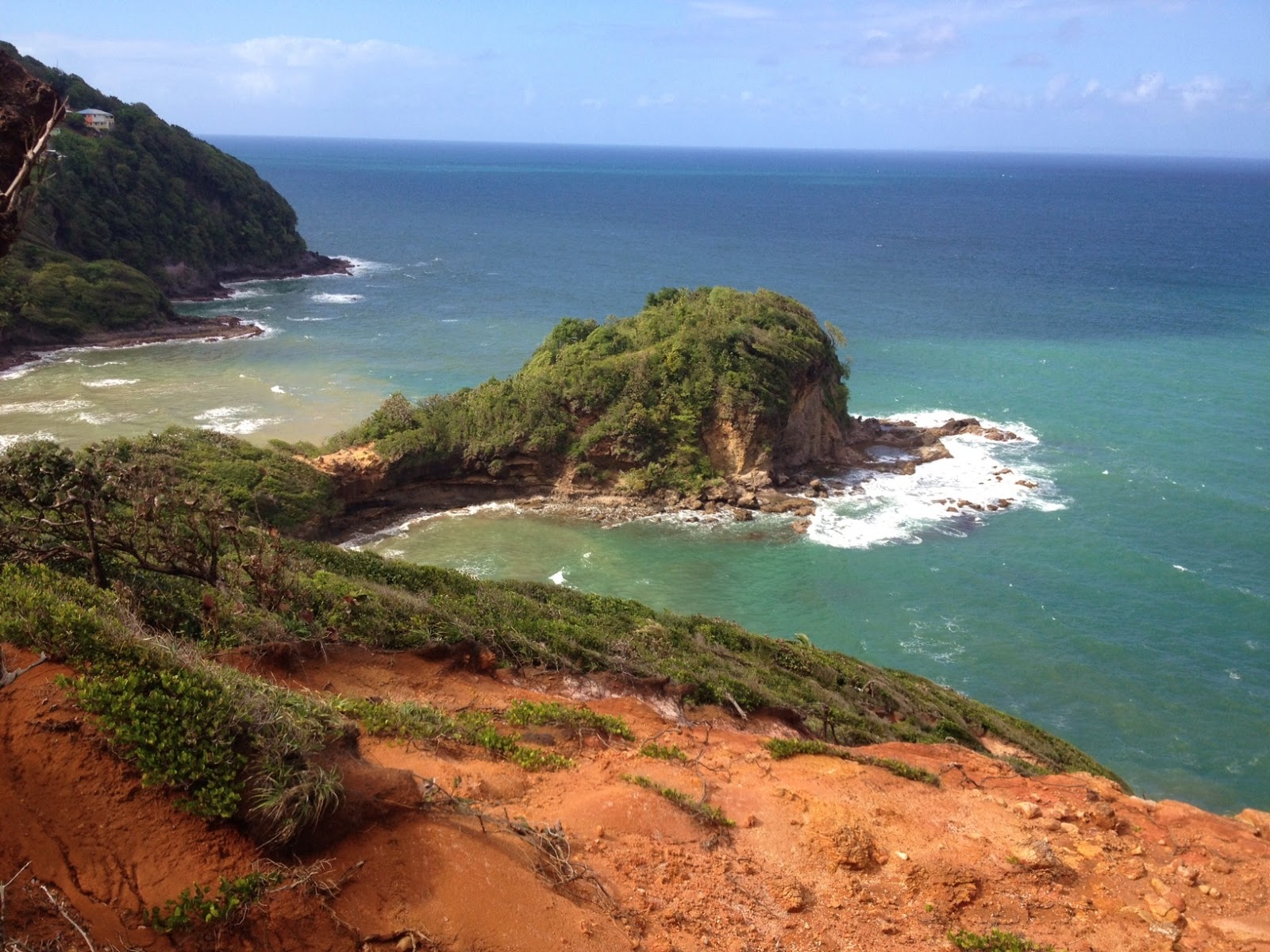
Most of the hike was under the canopy of the forest, limiting the ability to take good pictures of the amazing scenery we were seeing. However, at one point there was a clearing where I snapped this photo, looking down the coastline. This altitude lets one see much further down the coast than normal. Some of you may recognize (near the lower right center of the picture) the gray rocky point jutting out into the Atlantic Ocean that we call “Lion's Back” because it looks similar to the back end of a sitting lion, with the green trees filling in the lion's mane.

A lot of the hike along the ridges involved very steep slopes down both sides. One had to be very careful not to slip and fall. A few times our guide made suggestions about which side to favor, because falling down one way would be less problematical than slipping down the other side. Most of the time during these challenging sections, I didn't take time to pull out my camera, but below is one shot I took where we had to cross over a large rocky area, that had us crawling down for a brief period as we continued ascent. Notice the trunks of the trees on each side to get a sense of how narrow the apex of the ridge really was. Also notice that the machete (referred to as a cutlass here in the Caribbean) that our guide used to (somewhat) clear our path—and that my student is carrying his flip-flops in his left hand!

We finally arrived at the summit, and investigated the remnants of the old television tower. The picture below shows my student in the doorway of the small block building (which must have been very difficult to build, since the materials had to have been hand-carried to the top). [The first picture in this story also shows this small building behind me.] This small building is nearly as wide as the ridge--we passed it on the right side of this picture (because there was virtually space on the left side), and you can see how quickly the hillside drops on the right.

After climbing over two hours to reach the top, we headed back down the mountain. Climbing uphill can be exhausting, but going downhill under such conditions is no picnic. Sometimes I felt as if I were a slalom skier, zig-zagging down the hill by moving my hands from one tree to another. There were a few times where we slipped and fell, but fortunately there were no injuries (evacuating someone from that mountain would have been very difficult).
Part-way down the mountain, the ridge split, and we took a different route than the one we used for our ascent. We decided it would be easier to divert to a nearby small community (located higher above our village along the coast) and walk back home along the roadway. The picture above shows the view towards the north, where the biggest town in our district is located. Near the center of the picture is the large Catholic church located there (look for the green roof and pinkish walls).
Looking south off the other side, the picture above shows the view down the coast. You can see our guide with his cutlass at the bottom. Above his head and cutlass, you can see some of the houses in my village. In the upper right, you can see the conical mountain that seems so high when I've always viewed it before, but we are still higher than it is, even though we've probably descended hundreds of feet at this point.
The picture above is a zoomed in view from the same point as the pictures above. However, this one is special to me because I can pick out my house from this view (the Peace Corps prefers that I not identify my exact location, however.). It is fun to gaze upwards at the ridge now, because I can pick out this little clearing and remember what it was like to be up there "on top of the world."
Finally, we broke out of the forest (or bush, or jungle, or whatever you want to call it) into some former farm land (shown above). Soon we were on a small side road, and then we were hiking down the hill along the main road. It was an epic hike! It isn't on any tourism brochure for this island, but I had a great time and will always remember this day. I love exploring my local area! I will leave you with one last shot as we were coming down the narrow “spine” of the mountain, again showing how it slopes quickly down either side.